Mount Fuji is Japan's highest mountain at 3776m, a
volcano that last erupted in 1707 and which has long been sacred to the Japanese. They have been climbing it for centuries. I suspect it is the most climbed free standing mountain in the world.
I never had a view of Mt Fuji during my 12 day stay in Tokyo and Japan. That was despite climbing it and taking a trip up the Tokyo SkyTree (tallest communication tower in the world at 650m). Despite sweltering hot and humid days towards the end of August in Tokyo, the mountain was hidden by swathes of cloud each time I tried for a view. So, as an introduction, this is Mt Fuji as it could possibly be seen from the SkyTree (100km away) in Spring – at least this is the panaroma photo in the SkyTree:
One of the reasons it is accessible to young and old alike (I saw a 5 year old and 80+ year olds on the upper slopes) is that one can drive about halfway up: to the Fifth Station at 2300m. That removes any real glory in a summit of this impressive cone of solidified lava.
In order to do the mountain justice, one should, in my opinion, follow the old, original route – from the base of the mountain at the town of Fujiyoshida. The torii gate of Kanadorii, which marks the start of the sacred area of Mt Fuji, is roughly 800m above sea level. From here to the peak is just short of a 3km vertical ascent, a worthy climb.
This is the journey my hiking companion, Jules, suggested we take, and this is an account of our climb.
Day 1
Our journey started at the seaside town of Kamakura, and because the train ride had to boomerang via Yokohama it took us over 3 hours to get to Fujiyoshida, roughly the time it would take from central Tokyo. After picking up free, really good hiking information at the train station information centre, we checked into Pension Suwanomori, a lovely Japanese-style guest house at the Yoshida-Guchi trailhead.
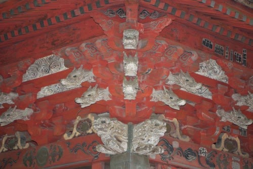
The guest house is also very close to the beautiful and elaborate Kitagushi Hongu Fuji Sengen Shrine, the start of the Yoshida-Guchi climbing trail. Here one offers prayers for safe passage to the spirits, although this can also be done at the Memorial Stone to the fallen climbers of Mt Fuji just up the road.
 |
| Not a swastika |
We then wondered into town, past the Kanadorii, in search of a meal of the traditional udon noodles eaten before the hike.
Day 2
After a good nights rest and a hearty breakfast, we shouldered our packs at 8am for the start of our 10 hour hike.
The first stop, after about 1.5 hours through Pine and Betula forests whistling with birds, is Nakanochaya tea house. The woods are meant to be home to Japanese Squirrel, Bears, Boars and Mountain Cats, but all we encountered was a frightened deer.
Still full of energy, with temperatures pleasant thanks to low lying cloud, we pressed on to Umagaeshi (1450m). The name of this station means something like 'horse turn-around' as horses were no longer allowed beyond this point. It was also the last place for free green-tea and water. Close by, an arch guarded by two cheeky stone-monkeys marks the route for every increasing prices for bottled water. Bottled water is about 120 yen from vending machines in town, costs 300 yen at the fifth station, and is 500 yen at the Fuji summit hut. Luckily, Jules was carrying kilograms of water.
We encountered our first hikers about fifteen minutes later at the 1st Station (or Ichi-gome 1530m). A veteran Japanese climber babbled away to us in Japanese, while another carrying the traditional walking stick with bells on to frighten bears took photos of the remnants of the shrine. By this time one has left the gentle incline of the lowlands, and every foot fall carries one skywards. In places the trail runs well below ground level, worn away by the millions of feet that have travelled this route through time. One passes the sites of many old tea-houses, which have become defunct with the road to the Fifth Station. The information signs include photos of a bustling route from a by-gone era.
One of these abandoned stations is the Second Station – Ni-gome – or the Women's Holy Ground. Up until the Edo Era (1832 ad) women were prohibited from climbing past this station and worshipped Mt Fuji from this point.
We emerged from the forests at the edge of the old Fifth Station at lunchtime. The squawk of a parrot led us to a station hut, where yummy Udon noodles were also on the Menu, which were a great supplement to the energy bars and other snack foods that had sustained us so far.
At the fifth station, things change dramatically from several points of view. There is a short transition zone from tropical woodlands to almost bare scree slopes of multi-coloured larva. But it is also where the crowds of people start, and they become the main source of entertainment for the rest of the journey upwards. The trail is clearly demarcated by erosion barriers or rope. Should you not have brought snacks or drinks, these are available at the many huts or sub-huts. Visits to pungent toilets now cost 200 yen.
At the sixth station is a mountain safety hut, where we were issued a pamphlet on the dangers of 'Bullet Climbing'. Those that head straight for the top are more likely to need first aid services, abandon the climb and generally get into trouble. However, the pace of the groups and the bottlenecks on the route mean that one is almost forced to climb at a healthy pace.
We arrived at the Goraikokan topmost mountain hut (3450m) with the last light of the day. These mountain huts pack over 100 people into a very tight space, and you don't really want to spend much time here, especially if you suffer from claustrophobia. One is literally shoulder-to-shoulder with one's neighbour. By comparison, the capsule I'd spent a week in Tokyo was spacious. In our case, we were in the 'attic' with less than 1 meter space between floor and ceiling – we literally had to crawl to our sleeping locations. An evening meal had been included in the price of our stay, and although it was presented t.v. Dinner style, it tasted good to our energy-deprived bodies.
Day 3
Exhaustion eventually ensured I got to sleep. However, many people have issues sleeping at altitude, and poor Jules had not slept at all by the time people started waking up at 2am. From Goraikokan it is only 1 hour to the summit, but the hut staff had suggested 2 hours may be necessary due to the large number of people. With dawn starting at 4.30 am, we were packed and ready by 2.30am.
Although the last stretch was punishing in the dark, cold, wet and wind, the ascent did only take just over an hour. So we reached the mountain top before 4am – but within minutes the warmth generated by the last leg of the climb had been blown away by the freezing wind and fog. We sought solice in the canteens for some expensive tea and soup, happily paying the inflated price for the warmth more than anything. But by 4:30 it was still pitch black outside with no sign the weather was going to improve. By 5:00am it was light enough to see, suggesting the sun had risen beyond the clouds, and we decided it was best to start our descent.
An hour later and we broke through the clouds for the first signs of a sunrise, and our first views of the five lakes region below us. For the next hour we would stop at the end of each zig of the descending zig-zag trail to distract ourselves from the knee-jarring descent with views of hilltops-islands in lakes of mist. The descent trail is separate from the ascent trail until the Sixth Station, which we reached around 7am.
Since we still had a day to fill before the grand finale of the day, I decided I would return through the forest to Fujiyoshida, in order to try and spot some of the birds we'd only heard singing the day before. As Jules had not slept at all, he opted for the bus from the Fifth Station, and relaxing and refreshing hot-bath.
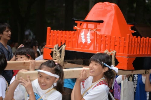
The grand finale for the day was the Yoshida No Himatsuri – or Fire Festival. This is held at the end of August and marks the end of the climbing season and the start of autumn.
The festival starts around 3.30pm at the Fuji Sengen Shrine, with crowds dressed mostly in white, loose fitting clothing with bells and head sashes. After a ceremony that transfers the spirits of the shrines to the elaborate arks, the procession sets off through the streets of town. For this ceremony, that happened to coincide with a thunder storm, and while the Japanese were well prepared with brollies and raincoats, Jules and I had left ours with our luggage in a locker at the train station, so had to seek shelter in the shrine for an hour or so while the rain wore itself out and had us seriously wondering how they would light the 70 or so three-meter tall pre-prepared bonfires that were the highlight of the evening.
Fortunately, the spirits were suitably appeased and by 5pm the streets were bustling with people examining the wares of the hundreds of street stalls, selling everything from gold-fish and turtles to octopus-on-a-stick. And by the time the last light of the day had died the first of the bonfires was on the go. The ceremony and festivals continue until midnight, and into the next day, but we'd had enough and it was time to head home to family and beds where one didn't feel the breathing of one's neighbour.
All in all, a most memorable expedition.
Notes on preparation.
I'm normally quite fit, as my work involves lots of hiking and outdoor activity generally. However, 2014 had been proving to be a bit of a laptop year, and in order to get ready for Mt Fuji I regularly hiked to the top of Blue Hill about once a week. Since this was all between 1000 and 1500 meters, I did not have problems with altitude sickness, which afflicts many, and which I have felt before.
The equipment list for climbing Mt Fuji includes the following:
1. Hiking Boots (good idea, although I saw some people did it in trainers)
2. Warm, layered clothing, including fleece and rain jacket and pants.
3. Gloves – both for keeping hands warm at altitude and protecting ones fingers against the sharp lava rocks.
4. Headlamp – especially for the night climb
5. Water – as much as you can comfortably carry, at least 1 litre.
6. Snacks – we carried dried fruit, energy bars, energy drinks and biscuits all bought locally in Japan at Familymart.
7. Cash – for water, tea and food at mountain huts (or using the toilet!)
8. Compass, Sunglasses and Sunblock were not needed by us – but could be useful.
9. Basic first aid kit (plasters, blister pads, headache tablets).
10. Tissues, toilet paper, toothbrush.
Remember, garbage in, garbage out – you need to carry all rubbish off the mountain – there are no bins.
 |
| Mt Fuji is clearly visible at 100km up on Google Earth. Fujiyoshida, the trail head is the grey area to the north between the lakes. |